logo
  • Home
  • Apps
  • Games
  • Latest Updated
  • Topics
login
logo
  • About Us
  • Disclaimer
  • DMCA
  • Guidance
  • Privacy Policy
  • Terms of Service
    youtubetwitterfacebook

Copy [email protected]. All Rights Reserved.

Google Play™ is a Trademark of Google Inc.

ApkFob is not affiliated with Google, Android OEMs or Android application developers in any way.

ADVERTISEMENT
Contour lines plugin — OsmAnd

Contour lines plugin — OsmAnd

Travel & Local

star3.9user100 mil+

Revisión del editor

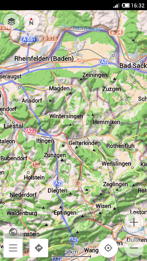
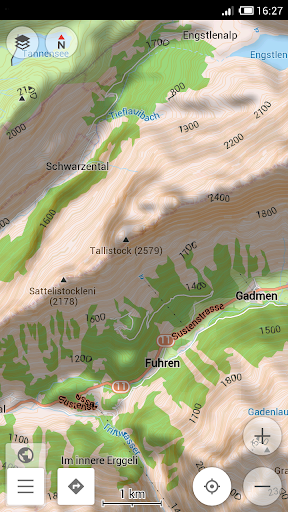
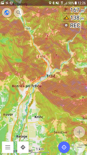
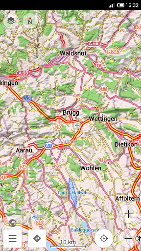
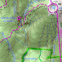
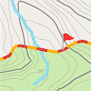
Contour lines plugin — OsmAnd is a plugin for 'Maps & Navigation — OsmAnd' app. The plugin provides extremely detailed offline topo maps that can be zoomed in and out without losing the quality. These topographic maps can also be complemented with a layer of 3D terrain representation ('hillshade'). Contour lines plugin — OsmAnd is a useful reference tool for hikers, tourists, cyclists, and any topography enthusiast. 
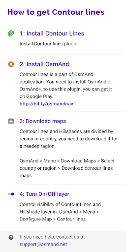
To download the contour lines and hillshade maps, please go to OsmAnd > Download maps > choose the country you need > Contour Lines/Hillshade. You can enable this layer of information by activating the plugin in OsmAnd > 'Plugins' and also enabling OsmAnd > Configure map > Contour Lines/Hillshade layer. The global data (between 70 degrees north and 70 degrees south) is based on measurements by SRTM (Shuttle Radar Topography Mission) and ASTER (Advanced Spaceborne Thermal Emission and Reflection Radiometer), an imaging instrument onboard Terra, the flagship satellite of NASA's Earth Observing System. ASTER is a cooperative effort between NASA, Japan's Ministry of Economy, Trade and Industry (METI), and Japan Space Systems (J-spacesystems).
ADVERTISEMENT
google play

Capturas de Pantalla

screenshots_0
screenshots_1
screenshots_2
screenshots_3
screenshots_4
screenshots_5

Recomendar

OruxMaps GP

OruxMaps GP

Travel & Local

star4.5

AlpineQuest Off-Road Explorer

AlpineQuest Off-Road Explorer

Maps & Navigation

star4.6

TrekMe - GPS trekking offline

TrekMe - GPS trekking offline

Maps & Navigation

star4.1

GPX Viewer PRO

GPX Viewer PRO

Maps & Navigation

star4.3

CityMaps2Go Offline maps

CityMaps2Go Offline maps

Maps & Navigation

star4.2

CarryMap

CarryMap

Maps & Navigation

star3.4

BackCountry Navigator GPS PRO

BackCountry Navigator GPS PRO

Maps & Navigation

star3.8

OsmAnd+ — Maps & GPS Offline

OsmAnd+ — Maps & GPS Offline

Travel & Local

star4.5

BackCountry Navigator XE: Topo

BackCountry Navigator XE: Topo

Maps & Navigation

star3.6

OsmAnd — Maps & GPS Offline

OsmAnd — Maps & GPS Offline

Travel & Local

star4.4

Mapstr

Mapstr

Travel & Local

star4.3

Avenza Maps: Offline Mapping

Avenza Maps: Offline Mapping

Maps & Navigation

star4.6