ADVERTISEMENT

GOHUNT / GPS Hunting Map
Maps & Navigation
![]() 4.5
4.5![]() 50 mil+
50 mil+
Revisión del editor
For all hunters who aspire to grow their skills and seek new adventures, GOHUNT is the most reliable interactive hunting platform because every aspect of its offerings is led by expert hunters and built by world-class technologists. Our tools serve hunters across their planning, preparation, scouting, mapping, and time in the field.
GOHUNT's hunting GPS maps are the best in class, and are built to withstand the harshest environments with or without cell service. Try it yourself with our 7-day free trial, and see firsthand why our maps are the most innovative solution for the challenges you face both in the field and planning from home.
Our Explorer subscription ($49 /year) gives you access to the following features to plan, prepare, and succeed on your next hunt. We currently provide coverage for 14 Western states, with expansion to all of the United States coming by hunting season 2022.
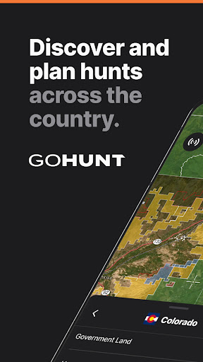
LAND BOUNDARIES
Public/private land boundaries, hunt units and districts, and more show you exactly where you can and can’t hunt
HUNTS
Plan and share your entire hunt plan with other GOHUNT users across all your devices (desktop and mobile)
IMPORT DATA
Simple data & waypoints import your from other mapping apps using a computer. Hunters can import any .gpx or .kml compatible file.
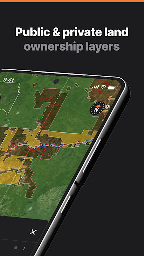
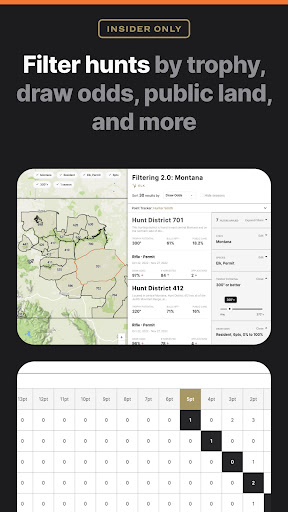
HUNTING LAYERS
Easily filter for public and private land, government land, walk-in access properties, hunt zones (antelope, bighorn sheep, deer, black bear, elk and more) with species distribution, hunt units, land usage (grazing allotments and timber cuts), terrain of upwards of 11,500 ft, unit boundaries, water, wildfire, trails, and more during your hunt
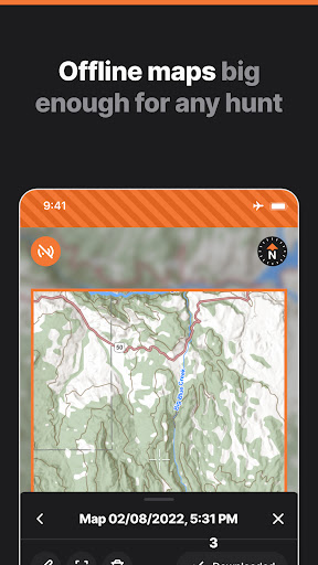
OFFLINE GPS MAPS
Download your hunting maps and confidently use your phone's GPS without cell service
3D TERRAIN
Visualize your approach with realistic terrain analysis
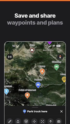
MAPPING TOOLS
Measure and mark your secret spots with waypoints, lines, tracks, photos, and more
BASEMAPS
The most accurate satellite and topographic maps with every detail you need for your hunt
RECORD TRACKS
Always find your way back to your camp with accurate GPS tracking
MAP SETTINGS
Ability to display map coordinates, crosshairs, outlines, open to last viewpoint, and more
By using our seamless hunting maps GPS to plan your hunt, you can focus on what really matters: getting into the field.
STATE COVERAGE
GOHUNT app features are available in Arizona, California, Colorado, Idaho, Montana, Nevada, New Mexico, Oregon, Utah, Washington and Wyoming. Features will be rolled out to the entire US by hunting season 2022.
ADVERTISEMENT
Capturas de Pantalla