ADVERTISEMENT

HuntStand: GPS Hunting Tools
Sports
![]() 4.3
4.3![]() 1 M+
1 M+
Revisión del editor
Outdoor Life Magazine Editors’ Choice for Best Hunting App. Featured in multiple publications as an invaluable tool.
HuntStand, with millions of downloads, is the #1 hunting app in North America and is the only hunting and land management app you will ever need. This revolutionary app is packed with invaluable mapping, weather, hunting tools, and social features.
Using this app, you will have access to offline maps and weather of your hunt areas. You can edit your maps while out “in the field” then sync them with your HuntStand account to further explore them online.
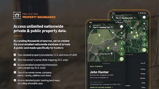
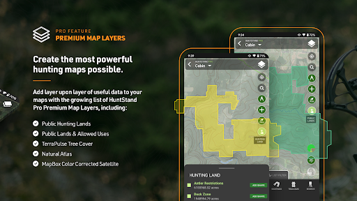
Gain access to searchable nationwide property boundary and owner information, our proprietary public hunting lands layer and several premium satellite & map layers.
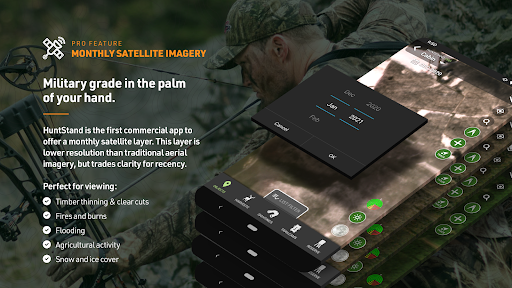
Get an up to date view with monthly satellite imagery.
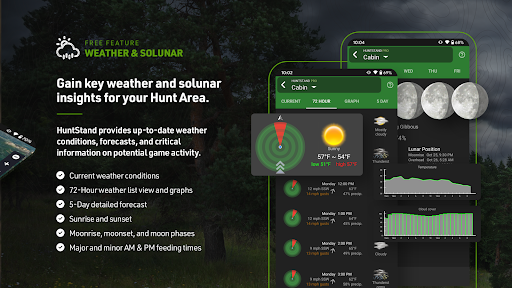
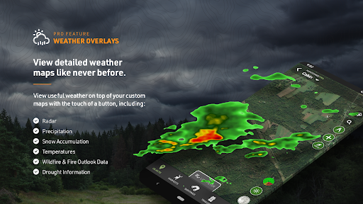
See granular weather using our advanced weather radar overlays, snow cover and more.
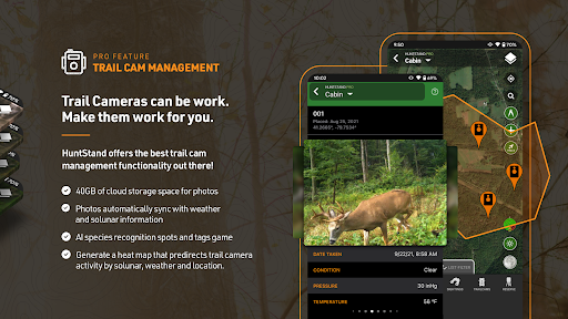
Log harvest, sightings, tasks and upload your trail camera photos to HuntStand.com to see incredible game movement insights and sync them to the HuntStand app.
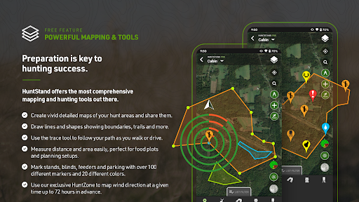
Fully map your property using more than 100 custom icons, shapes, and lines including scouting marks, stands, property boundaries, food plots, ponds, roads, trails, and many others.
View distance and area measurements using our advanced measurement tools. Our app will give you extremely accurate map-based distances in feet, meters, and yards and area measurements in acres.
Create an account and gain the ability to:
Sync Hunting Area maps with HuntStand.com
View and edit maps using ultra-advanced online mapping features
Share maps with friends
Create a personal profile
Add friends to your network
Locate your friends using the Friend Finder feature
Join group hunting areas (allowing you to share and edit maps with your hunting friends)
View advanced statistics built from your personal harvest and sighting history
In-app purchase available for HuntStand Pro
Order ultra-high-resolution printed maps through the HuntStand.com
HuntStand Pro includes:
No ads
Unlimited searchable property parcel queries across the country. View property boundaries, property size, and owner names. Add property boundaries to your custom maps.
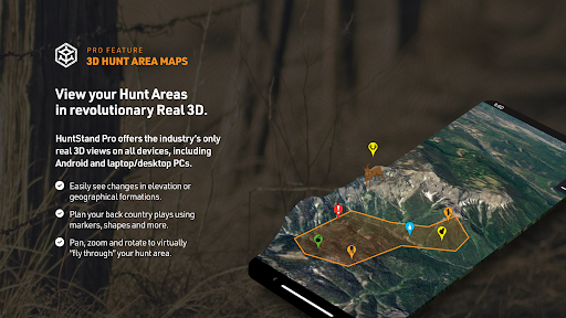
The ability to view your maps using our true 3D technology
Hunting Lands: State managed hunting land including WMAs, DNR boundaries, GMUs, hunting units, zones, districts, regions, boundaries with regulations, natural areas, conservation lands, habitats, and more
Public Lands: Federal, state, and county public lands including BLM, national and state forests and parks, Fish and Wildlife, DNR, conservation areas, public easements, and more
Tree Cover: Tree cover derived though analysis of NASA satellite imagery
Natural Atlas: Trails, ATV and 4x4 roads, forest roads, campgrounds, parks, natural points of interest, and more
Mapbox Satellite: Advanced Mapbox Satellite Imagery
Monthly satellite imagery
Advanced weather overlays including radar, snow cover and more
Payment will be charged to your PlayStore Account at confirmation of purchase;
Subscription automatically renews unless auto-renew is turned off at least 24-hours before the end of the current period
Your account will be charged for renewal within 24-hours prior to the end of the current period, and identify the cost of the renewal
You can manage subscriptions and turn auto-renewal off by going to your Account Settings after purchase
Any unused portion of a free trial period, if offered, will be forfeited when the you purchase a paid subscription
HuntStand’s Trace feature adds a path or line to your hunt area based on your specific movements. In order to enable this ability, HuntStand collects location data in the background. This includes while the app is not open, allowing users to utilize other aspects of their phone while a trace is being recorded.
Please read our privacy policy (https://huntstand.com/privacy) and terms & conditions (https://huntstand.com/terms-and-conditions)
ADVERTISEMENT
Capturas de Pantalla