ADVERTISEMENT

NOAA Marine Weather Forecast
Weather
![]() 3.9
3.9![]() 5 mil+
5 mil+
Revisión del editor
* Real-time marine weather buoy data
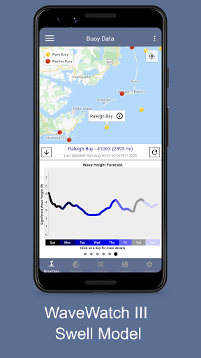
* 7-day hourly NOAA WAVEWATCH III Global Wave Model Forecast coupled to the Global Forecast System (GFSv16) provides more accurate marine data than the previous generation model!
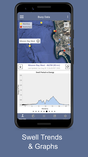
* 6-hour historical Wave height and Energy trend reports
* 7-day hourly harmonic tide forecast
* 48-hour tidal current forecast
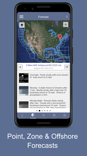
* 5-day National Weather Service marine weather forecast for point locations and weather zones and offshore zones
* Detailed NWS Forecast Discussion Reports
* Sunrise and Sunset times
* NOAA Severe Weather Reports
* NOAA HF Radar System for visualizing currents around many coastal US cities
* NEXRAD radar imagery and precipitation predictions
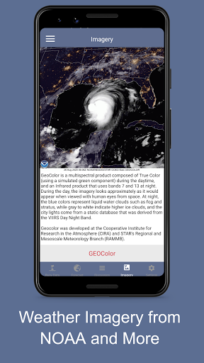
* GOES visibile, water vapor and infrared satellite imagery for the USA
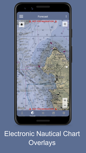
* NOAA Electronic Nautical Charts (ENC)
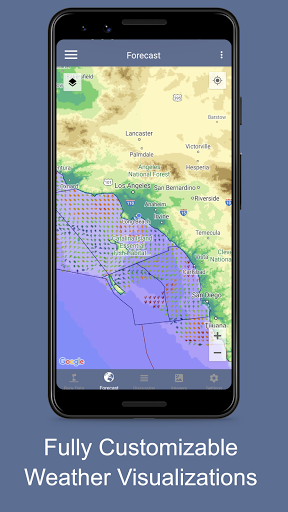
* Many additional map layers providing hazard areas, wave heights, temperatures, wind speeds and many others!
Real-time Data Includes:
- Primary and secondary swell height, period, direction
- Spectral wave energy density (wave energy vs period)
- Significant wave height
- Wind speed, gust and direction
- Air temperature
- Water temperature
- Pressure
- Sunrise/Sunset times
- Current NWS Alerts
*Built-in Imagery viewer, including
- Satellite Imagery from the GOES-West and GOES-East Satellites
- WAVEWATCHIII Forecast Model Plots
- Nearshore Wave Prediction Plots
- ESTOFS Storm Surge & Tidal Flow Plots
- Many more to come soon!!
6-hour Historical Trend Data Includes:
- Primary and secondary wave height, period, direction
- Wave energy, period, direction
7-day NOAA WAVEWATCH III Global Wave Model Forecast Includes:
- Hourly swell component predictions (1-6 swells)
- Accurate wave height, period, direction predictions
7-day Hourly Harmonic Tide Forecast Includes:
- Interactive tide graphs
- Hourly tide predictions
- Current tide
48-hour Tidal Current Forecast Includes:
- Interactive graph to represent speed of the tide, in knots
- Hourly tidal current predictions
- Current tidal flow
5-day NWS Marine Forecast Includes:
- Text summary forecast
- Weather, sky, wind, waves
- Click any point on the map
Sunrise/Sunset Times Includes:
- Astronomical Twilight
- Nautical Twilight
- Civil Twilight
- Sunrise/Sunset
- Solar Noon
Real-time Radar and Satellite Imagery:
- HF Radar Real-time current flow velocity vectors
- HF Radar 12-hour averaged current flow velocity vector
- NEXRAD Composite Base Reflectivity
- NEXRAD Base Reflectivity
- NEXRAD Echo Tops EET
- HRRR Reflectivity Forecasts
- GOES North America, Hawaii and Alaska Visible
- GOES North America, Hawaii and Alaska Infrared
- GOES North America, Hawaii and Alaska Water Vapor
- Hybrid-Scan Reflectivity Composite
- 1-Hour Precipitation Forecast
- 24-Hour Precipitation Forecast
- 48-Hour Precipitation Forecast
- 72-Hour Precipitation Forecast
GIS Mapping System using real-time data from NOAA, including:
- NOAA Marine Zones
- NOAA HD Radar
- NEXRAD 4-bit Base Reflectivity
- NEXRAD 8-bit Base Reflectivity
- NEXRAD Echo Tops EET
- HRRR Reflectivity Forecasts
- MRMS Hybrid-Scan Reflectivity
- Long-Duration Hazards
- Short-Duration Watches & Warnings
- Significant Wave Height
- HF Radar Vectors (Surface Currents)
- Total Water Level (Tides + Surge)
- Tidal Water Level
- Water Level Surge
- Tropical Cyclone Track Forecasts
- Tropical Cyclone Best Track Analysis
- Wind Speed & Direction
- Wind Gust & Direction
- Severe Thunderstorm Outlook
- 15 minute Lightning Strike Density
- Surface Visibility
- Sea Surface Water Currents (w/ Speed)
- Total Cloud Cover (%)
- Air Temperature
- Sea Surface Temperature
- Relative Humidity
- Dew Point Temperature
- 12-hour rain probability
- 1/3/6/12/24/48/72 Hour Precipitation Accumulation
- GOES Northern Hemisphere Satellite Imagery
- National Grid
- Electronic Nautical Charts (ENC)
Please remember that this app can only show data the buoy collects. Not all buoys collect weather data. Not all buoys collect wave data.
ADVERTISEMENT
Capturas de Pantalla